|
|
|||||||||||||||||
| Point ID: 9357 | Downloads | Plots | Site Data | Code: 15303700 |
|
|
|||||||||||||||||
| Download | |
|---|---|
| Site Descriptor Information | Site Time Series Data |
| Link to all available data | |
| View: | Time Series | All |
| Units: | mm |
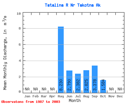
| Statistic | Jan | Feb | Mar | Apr | May | Jun | Jul | Aug | Sep | Oct | Nov | Dec | Annual |
|---|---|---|---|---|---|---|---|---|---|---|---|---|---|
| Mean | 8.23 | 2.79 | 2.38 | 2.83 | 3.38 | 1.58 | |||||||
| Standard Deviation | 2.99 | 1.10 | 1.61 | 1.53 | 2.71 | 0.55 | |||||||
| Min | 4.17 | 1.22 | 0.57 | 0.57 | 0.64 | 0.52 | |||||||
| Max | 14.30 | 4.66 | 5.91 | 6.01 | 11.64 | 2.38 | |||||||
| Coefficient of Variation | 0.36 | 0.40 | 0.68 | 0.54 | 0.80 | 0.34 |
 Return to R-Arctic Net Home Page