|
|
|||||||||||||||||
| Point ID: 9357 | Downloads | Plots | Site Data | Code: 15303700 |
|
|
|||||||||||||||||
| Download | |
|---|---|
| Site Descriptor Information | Site Time Series Data |
| Link to all available data | |
| View: | Time Series | All |
| Units: | m3/s |
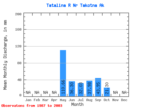
| Statistic | Jan | Feb | Mar | Apr | May | Jun | Jul | Aug | Sep | Oct | Nov | Dec | Annual |
|---|---|---|---|---|---|---|---|---|---|---|---|---|---|
| Mean | 110.64 | 36.31 | 32.02 | 37.97 | 43.95 | 21.29 | |||||||
| Standard Deviation | 40.25 | 14.36 | 21.63 | 20.61 | 35.22 | 7.34 | |||||||
| Min | 56.04 | 15.88 | 7.73 | 7.64 | 8.28 | 7.04 | |||||||
| Max | 192.31 | 60.66 | 79.40 | 80.85 | 151.51 | 31.95 | |||||||
| Coefficient of Variation | 0.36 | 0.40 | 0.68 | 0.54 | 0.80 | 0.34 |
 Return to R-Arctic Net Home Page