|
|
|||||||||||||||||
| Point ID: 9345 | Downloads | Plots | Site Data | Code: 15304000 |
|
|
|||||||||||||||||
| Download | |
|---|---|
| Site Descriptor Information | Site Time Series Data |
| Link to all available data | |
| View: | Time Series | All |
| Units: | mm |
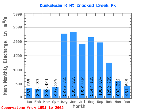
| Statistic | Jan | Feb | Mar | Apr | May | Jun | Jul | Aug | Sep | Oct | Nov | Dec | Annual |
|---|---|---|---|---|---|---|---|---|---|---|---|---|---|
| Mean | 367.09 | 328.13 | 302.42 | 407.33 | 2275.76 | 2337.25 | 1922.03 | 2147.18 | 1960.09 | 1252.73 | 603.36 | 431.65 | 1189.78 |
| Standard Deviation | 78.74 | 68.43 | 72.17 | 188.62 | 935.54 | 952.70 | 471.95 | 669.37 | 743.77 | 445.94 | 143.27 | 95.20 | 207.60 |
| Min | 237.86 | 195.39 | 172.73 | 243.53 | 626.62 | 959.38 | 1158.52 | 1184.83 | 865.17 | 641.24 | 360.57 | 283.17 | 756.10 |
| Max | 635.76 | 586.56 | 553.55 | 1160.99 | 4577.65 | 6656.35 | 3383.95 | 4807.10 | 4271.88 | 2887.77 | 1030.73 | 707.92 | 1788.13 |
| Coefficient of Variation | 0.21 | 0.21 | 0.24 | 0.46 | 0.41 | 0.41 | 0.25 | 0.31 | 0.38 | 0.36 | 0.24 | 0.22 | 0.17 |
 Return to R-Arctic Net Home Page