|
|
|||||||||||||||||
| Point ID: 9345 | Downloads | Plots | Site Data | Code: 15304000 |
|
|
|||||||||||||||||
| Download | |
|---|---|
| Site Descriptor Information | Site Time Series Data |
| Link to all available data | |
| View: | Time Series | All |
| Units: | m3/s |
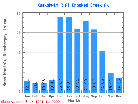
| Statistic | Jan | Feb | Mar | Apr | May | Jun | Jul | Aug | Sep | Oct | Nov | Dec | Annual |
|---|---|---|---|---|---|---|---|---|---|---|---|---|---|
| Mean | 12.21 | 9.94 | 10.05 | 13.11 | 75.66 | 75.21 | 63.90 | 71.39 | 63.08 | 41.65 | 19.42 | 14.35 | 466.17 |
| Standard Deviation | 2.62 | 2.07 | 2.40 | 6.07 | 31.10 | 30.66 | 15.69 | 22.25 | 23.93 | 14.83 | 4.61 | 3.17 | 81.34 |
| Min | 7.91 | 5.92 | 5.74 | 7.84 | 20.83 | 30.87 | 38.52 | 39.39 | 27.84 | 21.32 | 11.60 | 9.41 | 296.25 |
| Max | 21.14 | 17.77 | 18.40 | 37.36 | 152.19 | 214.20 | 112.51 | 159.82 | 137.47 | 96.01 | 33.17 | 23.54 | 700.61 |
| Coefficient of Variation | 0.21 | 0.21 | 0.24 | 0.46 | 0.41 | 0.41 | 0.25 | 0.31 | 0.38 | 0.36 | 0.24 | 0.22 | 0.17 |
 Return to R-Arctic Net Home Page