|
|
|||||||||||||||||
| Point ID: 9343 | Downloads | Plots | Site Data | Code: 15303600 |
|
|
|||||||||||||||||
| Download | |
|---|---|
| Site Descriptor Information | Site Time Series Data |
| Link to all available data | |
| View: | Time Series | All |
| Units: | mm |
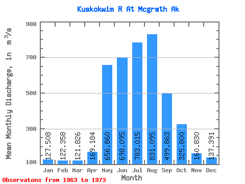
| Statistic | Jan | Feb | Mar | Apr | May | Jun | Jul | Aug | Sep | Oct | Nov | Dec | Annual |
|---|---|---|---|---|---|---|---|---|---|---|---|---|---|
| Mean | 127.51 | 122.36 | 121.83 | 169.18 | 656.86 | 698.10 | 783.01 | 831.10 | 499.86 | 325.80 | 160.83 | 137.39 | 381.55 |
| Standard Deviation | 19.79 | 20.29 | 22.78 | 59.05 | 318.95 | 313.19 | 199.81 | 327.86 | 160.80 | 101.51 | 23.30 | 20.39 | 80.39 |
| Min | 107.60 | 90.61 | 79.29 | 109.02 | 169.90 | 351.32 | 587.35 | 558.02 | 290.91 | 223.03 | 128.75 | 111.71 | 273.97 |
| Max | 167.07 | 161.41 | 155.74 | 328.48 | 1123.90 | 1385.64 | 1136.51 | 1466.08 | 834.40 | 534.18 | 203.88 | 175.56 | 519.10 |
| Coefficient of Variation | 0.15 | 0.17 | 0.19 | 0.35 | 0.49 | 0.45 | 0.26 | 0.39 | 0.32 | 0.31 | 0.14 | 0.15 | 0.21 |
 Return to R-Arctic Net Home Page