|
|
|||||||||||||||||
| Point ID: 9343 | Downloads | Plots | Site Data | Code: 15303600 |
|
|
|||||||||||||||||
| Download | |
|---|---|
| Site Descriptor Information | Site Time Series Data |
| Link to all available data | |
| View: | Time Series | All |
| Units: | m3/s |
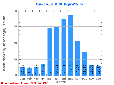
| Statistic | Jan | Feb | Mar | Apr | May | Jun | Jul | Aug | Sep | Oct | Nov | Dec | Annual |
|---|---|---|---|---|---|---|---|---|---|---|---|---|---|
| Mean | 11.27 | 9.85 | 10.77 | 14.47 | 58.05 | 59.71 | 69.20 | 73.45 | 42.76 | 28.79 | 13.76 | 12.14 | 397.37 |
| Standard Deviation | 1.75 | 1.63 | 2.01 | 5.05 | 28.19 | 26.79 | 17.66 | 28.98 | 13.76 | 8.97 | 1.99 | 1.80 | 83.73 |
| Min | 9.51 | 7.30 | 7.01 | 9.32 | 15.02 | 30.05 | 51.91 | 49.31 | 24.88 | 19.71 | 11.01 | 9.87 | 285.33 |
| Max | 14.77 | 13.00 | 13.76 | 28.10 | 99.32 | 118.52 | 100.44 | 129.56 | 71.37 | 47.21 | 17.44 | 15.52 | 540.64 |
| Coefficient of Variation | 0.15 | 0.17 | 0.19 | 0.35 | 0.49 | 0.45 | 0.26 | 0.39 | 0.32 | 0.31 | 0.14 | 0.15 | 0.21 |
 Return to R-Arctic Net Home Page