|
|
|||||||||||||||||
| Point ID: 9338 | Downloads | Plots | Site Data | Code: 15303000 |
|
|
|||||||||||||||||
| Download | |
|---|---|
| Site Descriptor Information | Site Time Series Data |
| Link to all available data | |
| View: | Time Series | All |
| Units: | mm |
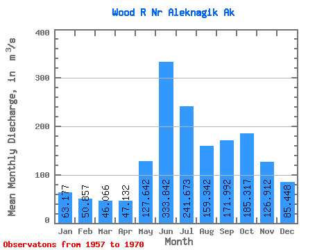
| Statistic | Jan | Feb | Mar | Apr | May | Jun | Jul | Aug | Sep | Oct | Nov | Dec | Annual |
|---|---|---|---|---|---|---|---|---|---|---|---|---|---|
| Mean | 63.18 | 50.86 | 46.07 | 47.13 | 127.64 | 333.84 | 241.67 | 159.34 | 171.99 | 185.32 | 126.91 | 85.45 | 134.09 |
| Standard Deviation | 24.63 | 19.40 | 18.01 | 18.85 | 38.32 | 85.84 | 58.31 | 31.51 | 49.16 | 53.51 | 49.88 | 37.16 | 22.23 |
| Min | 27.45 | 20.58 | 19.82 | 22.23 | 28.03 | 226.63 | 142.89 | 120.19 | 110.77 | 96.16 | 70.79 | 45.31 | 100.58 |
| Max | 118.56 | 98.00 | 88.60 | 83.22 | 158.43 | 520.84 | 370.38 | 212.60 | 269.48 | 279.10 | 232.91 | 179.31 | 169.32 |
| Coefficient of Variation | 0.39 | 0.38 | 0.39 | 0.40 | 0.30 | 0.26 | 0.24 | 0.20 | 0.29 | 0.29 | 0.39 | 0.43 | 0.17 |
 Return to R-Arctic Net Home Page