|
|
|||||||||||||||||
| Point ID: 9338 | Downloads | Plots | Site Data | Code: 15303000 |
|
|
|||||||||||||||||
| Download | |
|---|---|
| Site Descriptor Information | Site Time Series Data |
| Link to all available data | |
| View: | Time Series | All |
| Units: | m3/s |
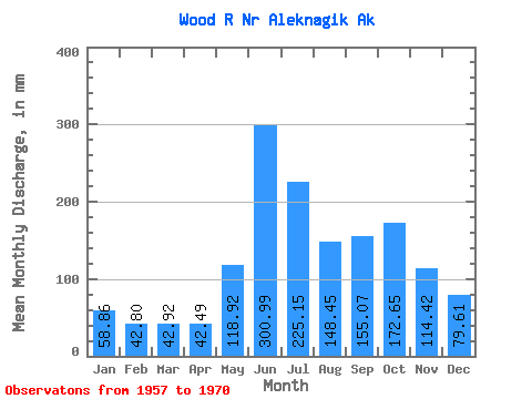
| Statistic | Jan | Feb | Mar | Apr | May | Jun | Jul | Aug | Sep | Oct | Nov | Dec | Annual |
|---|---|---|---|---|---|---|---|---|---|---|---|---|---|
| Mean | 58.85 | 43.16 | 42.91 | 42.49 | 118.90 | 300.99 | 225.12 | 148.43 | 155.07 | 172.62 | 114.42 | 79.60 | 1472.02 |
| Standard Deviation | 22.94 | 16.47 | 16.77 | 17.00 | 35.70 | 77.39 | 54.32 | 29.35 | 44.33 | 49.85 | 44.97 | 34.62 | 244.04 |
| Min | 25.57 | 17.47 | 18.46 | 20.04 | 26.11 | 204.33 | 133.10 | 111.96 | 99.87 | 89.57 | 63.83 | 42.20 | 1104.17 |
| Max | 110.44 | 83.17 | 82.54 | 75.03 | 147.58 | 469.59 | 345.01 | 198.03 | 242.96 | 259.99 | 209.99 | 167.03 | 1858.79 |
| Coefficient of Variation | 0.39 | 0.38 | 0.39 | 0.40 | 0.30 | 0.26 | 0.24 | 0.20 | 0.29 | 0.29 | 0.39 | 0.43 | 0.17 |
 Return to R-Arctic Net Home Page