|
|
|||||||||||||||||
| Point ID: 9316 | Downloads | Plots | Site Data | Code: 15056200 |
|
|
|||||||||||||||||
| Download | |
|---|---|
| Site Descriptor Information | Site Time Series Data |
| Link to all available data | |
| View: | Time Series | All |
| Units: | mm |
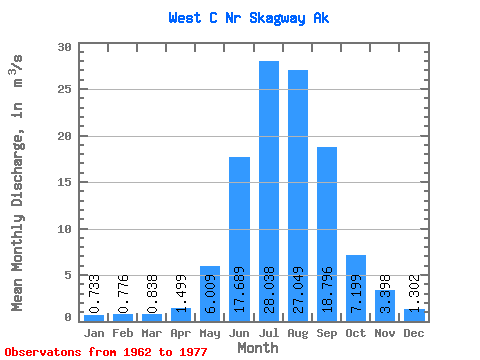
| Statistic | Jan | Feb | Mar | Apr | May | Jun | Jul | Aug | Sep | Oct | Nov | Dec | Annual |
|---|---|---|---|---|---|---|---|---|---|---|---|---|---|
| Mean | 0.73 | 0.78 | 0.84 | 1.50 | 6.01 | 17.69 | 28.04 | 27.05 | 18.80 | 7.20 | 3.40 | 1.30 | 9.29 |
| Standard Deviation | 0.53 | 0.61 | 0.55 | 0.68 | 1.78 | 4.41 | 4.20 | 5.97 | 7.11 | 2.32 | 2.25 | 0.88 | 1.01 |
| Min | 0.23 | 0.38 | 0.24 | 0.53 | 4.05 | 13.09 | 20.72 | 17.39 | 10.15 | 3.27 | 0.92 | 0.41 | 7.41 |
| Max | 2.21 | 2.71 | 2.06 | 3.02 | 10.81 | 28.43 | 33.40 | 37.28 | 36.40 | 11.04 | 7.47 | 3.34 | 11.26 |
| Coefficient of Variation | 0.73 | 0.79 | 0.65 | 0.45 | 0.30 | 0.25 | 0.15 | 0.22 | 0.38 | 0.32 | 0.66 | 0.68 | 0.11 |
 Return to R-Arctic Net Home Page