|
|
|||||||||||||||||
| Point ID: 9316 | Downloads | Plots | Site Data | Code: 15056200 |
|
|
|||||||||||||||||
| Download | |
|---|---|
| Site Descriptor Information | Site Time Series Data |
| Link to all available data | |
| View: | Time Series | All |
| Units: | m3/s |
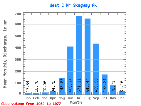
| Statistic | Jan | Feb | Mar | Apr | May | Jun | Jul | Aug | Sep | Oct | Nov | Dec | Annual |
|---|---|---|---|---|---|---|---|---|---|---|---|---|---|
| Mean | 17.55 | 16.92 | 20.06 | 34.72 | 143.80 | 409.75 | 671.01 | 647.34 | 435.38 | 172.30 | 78.72 | 31.17 | 2618.88 |
| Standard Deviation | 12.77 | 13.42 | 13.07 | 15.70 | 42.53 | 102.14 | 100.58 | 142.98 | 164.61 | 55.51 | 52.20 | 21.08 | 286.12 |
| Min | 5.44 | 8.27 | 5.86 | 12.18 | 96.93 | 303.23 | 495.92 | 416.20 | 235.06 | 78.26 | 21.21 | 9.81 | 2090.93 |
| Max | 53.01 | 59.21 | 49.42 | 69.88 | 258.70 | 658.41 | 799.21 | 892.16 | 843.18 | 264.12 | 173.08 | 79.99 | 3175.40 |
| Coefficient of Variation | 0.73 | 0.79 | 0.65 | 0.45 | 0.30 | 0.25 | 0.15 | 0.22 | 0.38 | 0.32 | 0.66 | 0.68 | 0.11 |
 Return to R-Arctic Net Home Page