|
|
|||||||||||||||||
| Point ID: 9301 | Downloads | Plots | Site Data | Code: 15085100 |
|
|
|||||||||||||||||
| Download | |
|---|---|
| Site Descriptor Information | Site Time Series Data |
| Link to all available data | |
| View: | Time Series | All |
| Units: | mm |
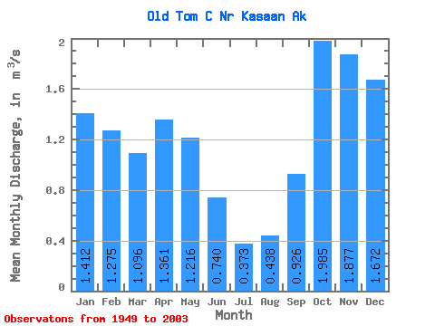
| Statistic | Jan | Feb | Mar | Apr | May | Jun | Jul | Aug | Sep | Oct | Nov | Dec | Annual |
|---|---|---|---|---|---|---|---|---|---|---|---|---|---|
| Mean | 1.41 | 1.27 | 1.10 | 1.36 | 1.22 | 0.74 | 0.37 | 0.44 | 0.93 | 1.98 | 1.88 | 1.67 | 1.20 |
| Standard Deviation | 0.91 | 0.76 | 0.63 | 0.51 | 0.51 | 0.33 | 0.19 | 0.35 | 0.56 | 0.78 | 0.92 | 0.87 | 0.25 |
| Min | 0.09 | 0.14 | 0.28 | 0.54 | 0.43 | 0.15 | 0.08 | 0.05 | 0.08 | 0.65 | 0.48 | 0.23 | 0.71 |
| Max | 3.62 | 3.32 | 2.44 | 3.46 | 2.81 | 1.59 | 0.88 | 1.44 | 2.65 | 4.63 | 4.70 | 3.87 | 2.05 |
| Coefficient of Variation | 0.65 | 0.60 | 0.57 | 0.38 | 0.42 | 0.44 | 0.50 | 0.80 | 0.60 | 0.39 | 0.49 | 0.52 | 0.21 |
 Return to R-Arctic Net Home Page