|
|
|||||||||||||||||
| Point ID: 9301 | Downloads | Plots | Site Data | Code: 15085100 |
|
|
|||||||||||||||||
| Download | |
|---|---|
| Site Descriptor Information | Site Time Series Data |
| Link to all available data | |
| View: | Time Series | All |
| Units: | m3/s |
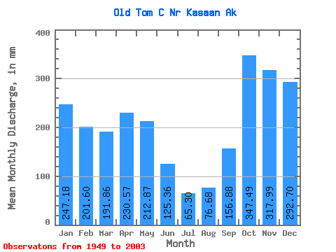
| Statistic | Jan | Feb | Mar | Apr | May | Jun | Jul | Aug | Sep | Oct | Nov | Dec | Annual |
|---|---|---|---|---|---|---|---|---|---|---|---|---|---|
| Mean | 247.11 | 203.32 | 191.91 | 230.64 | 212.91 | 125.40 | 65.21 | 76.62 | 156.95 | 347.43 | 318.01 | 292.67 | 2464.87 |
| Standard Deviation | 159.78 | 121.41 | 109.91 | 86.61 | 89.39 | 55.59 | 32.76 | 61.32 | 94.32 | 136.67 | 156.51 | 151.75 | 514.33 |
| Min | 14.88 | 22.65 | 49.89 | 91.47 | 74.54 | 26.15 | 13.30 | 8.94 | 12.93 | 114.17 | 81.79 | 41.08 | 1456.70 |
| Max | 633.62 | 529.15 | 427.68 | 585.59 | 491.00 | 269.14 | 153.68 | 252.40 | 449.00 | 809.96 | 796.82 | 677.57 | 4221.79 |
| Coefficient of Variation | 0.65 | 0.60 | 0.57 | 0.38 | 0.42 | 0.44 | 0.50 | 0.80 | 0.60 | 0.39 | 0.49 | 0.52 | 0.21 |
 Return to R-Arctic Net Home Page