|
|
|||||||||||||||||
| Point ID: 9291 | Downloads | Plots | Site Data | Code: 15081500 |
|
|
|||||||||||||||||
| Download | |
|---|---|
| Site Descriptor Information | Site Time Series Data |
| Link to all available data | |
| View: | Time Series | All |
| Units: | mm |
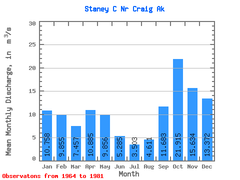
| Statistic | Jan | Feb | Mar | Apr | May | Jun | Jul | Aug | Sep | Oct | Nov | Dec | Annual |
|---|---|---|---|---|---|---|---|---|---|---|---|---|---|
| Mean | 10.76 | 9.86 | 7.46 | 10.88 | 9.86 | 5.29 | 3.50 | 4.61 | 11.68 | 21.91 | 15.63 | 13.37 | 10.46 |
| Standard Deviation | 7.51 | 4.61 | 2.85 | 6.57 | 4.32 | 1.90 | 2.03 | 2.56 | 7.39 | 8.93 | 8.53 | 7.96 | 1.12 |
| Min | 0.68 | 0.45 | 2.90 | 4.14 | 3.29 | 1.71 | 1.07 | 0.67 | 0.67 | 7.83 | 4.15 | 3.20 | 7.96 |
| Max | 25.37 | 18.01 | 12.36 | 32.61 | 18.66 | 8.60 | 8.16 | 10.18 | 25.96 | 43.77 | 38.91 | 32.09 | 12.48 |
| Coefficient of Variation | 0.70 | 0.47 | 0.38 | 0.60 | 0.44 | 0.36 | 0.58 | 0.56 | 0.63 | 0.41 | 0.55 | 0.59 | 0.11 |
 Return to R-Arctic Net Home Page