|
|
|||||||||||||||||
| Point ID: 9291 | Downloads | Plots | Site Data | Code: 15081500 |
|
|
|||||||||||||||||
| Download | |
|---|---|
| Site Descriptor Information | Site Time Series Data |
| Link to all available data | |
| View: | Time Series | All |
| Units: | m3/s |
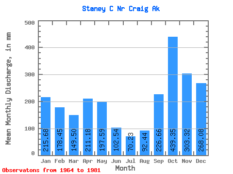
| Statistic | Jan | Feb | Mar | Apr | May | Jun | Jul | Aug | Sep | Oct | Nov | Dec | Annual |
|---|---|---|---|---|---|---|---|---|---|---|---|---|---|
| Mean | 215.63 | 179.99 | 149.47 | 211.18 | 197.56 | 102.54 | 70.22 | 92.44 | 226.66 | 439.28 | 303.32 | 268.04 | 2472.02 |
| Standard Deviation | 150.58 | 84.15 | 57.10 | 127.47 | 86.67 | 36.84 | 40.77 | 51.29 | 143.35 | 178.93 | 165.53 | 159.47 | 263.88 |
| Min | 13.68 | 8.18 | 58.06 | 80.39 | 65.99 | 33.15 | 21.41 | 13.39 | 13.07 | 156.92 | 80.59 | 64.08 | 1879.73 |
| Max | 508.58 | 329.01 | 247.70 | 632.59 | 373.98 | 166.79 | 163.49 | 203.99 | 503.69 | 877.45 | 754.92 | 643.17 | 2949.32 |
| Coefficient of Variation | 0.70 | 0.47 | 0.38 | 0.60 | 0.44 | 0.36 | 0.58 | 0.56 | 0.63 | 0.41 | 0.55 | 0.59 | 0.11 |
 Return to R-Arctic Net Home Page