|
|
|||||||||||||||||
| Point ID: 9287 | Downloads | Plots | Site Data | Code: 15080000 |
|
|
|||||||||||||||||
| Download | |
|---|---|
| Site Descriptor Information | Site Time Series Data |
| Link to all available data | |
| View: | Time Series | All |
| Units: | mm |
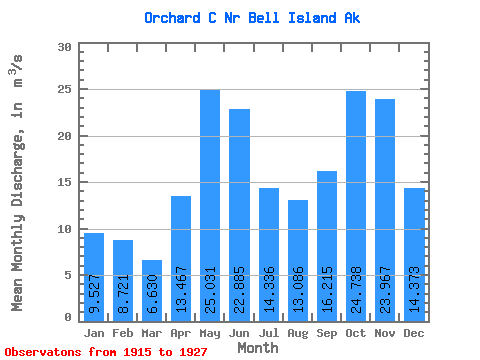
| Statistic | Jan | Feb | Mar | Apr | May | Jun | Jul | Aug | Sep | Oct | Nov | Dec | Annual |
|---|---|---|---|---|---|---|---|---|---|---|---|---|---|
| Mean | 9.53 | 8.72 | 6.63 | 13.47 | 25.03 | 22.89 | 14.34 | 13.09 | 16.21 | 24.74 | 23.97 | 14.37 | 16.34 |
| Standard Deviation | 9.05 | 6.17 | 3.94 | 5.66 | 4.99 | 5.64 | 4.83 | 6.92 | 7.70 | 10.29 | 14.53 | 7.97 | 1.89 |
| Min | 1.82 | 1.07 | 1.86 | 8.29 | 16.99 | 9.35 | 6.77 | 5.07 | 5.37 | 9.30 | 11.14 | 5.12 | 13.57 |
| Max | 33.98 | 20.25 | 16.42 | 26.55 | 33.50 | 29.60 | 25.24 | 25.61 | 26.81 | 41.31 | 62.30 | 31.18 | 19.57 |
| Coefficient of Variation | 0.95 | 0.71 | 0.59 | 0.42 | 0.20 | 0.25 | 0.34 | 0.53 | 0.47 | 0.42 | 0.61 | 0.55 | 0.12 |
 Return to R-Arctic Net Home Page