|
|
|||||||||||||||||
| Point ID: 9287 | Downloads | Plots | Site Data | Code: 15080000 |
|
|
|||||||||||||||||
| Download | |
|---|---|
| Site Descriptor Information | Site Time Series Data |
| Link to all available data | |
| View: | Time Series | All |
| Units: | m3/s |
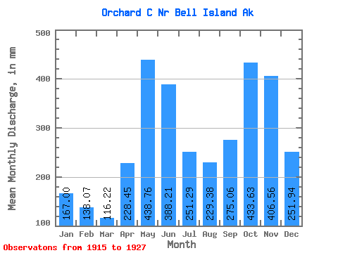
| Statistic | Jan | Feb | Mar | Apr | May | Jun | Jul | Aug | Sep | Oct | Nov | Dec | Annual |
|---|---|---|---|---|---|---|---|---|---|---|---|---|---|
| Mean | 166.98 | 139.26 | 116.19 | 228.45 | 438.70 | 388.21 | 251.26 | 229.35 | 275.06 | 433.57 | 406.56 | 251.91 | 3375.95 |
| Standard Deviation | 158.57 | 98.61 | 69.00 | 95.98 | 87.50 | 95.70 | 84.56 | 121.31 | 130.64 | 180.26 | 246.42 | 139.64 | 390.22 |
| Min | 31.88 | 17.12 | 32.53 | 140.53 | 297.77 | 158.52 | 118.60 | 88.93 | 91.14 | 162.99 | 188.90 | 89.77 | 2802.25 |
| Max | 595.54 | 323.42 | 287.74 | 450.41 | 587.19 | 502.08 | 442.36 | 448.80 | 454.81 | 723.99 | 1056.77 | 546.49 | 4041.01 |
| Coefficient of Variation | 0.95 | 0.71 | 0.59 | 0.42 | 0.20 | 0.25 | 0.34 | 0.53 | 0.47 | 0.42 | 0.61 | 0.55 | 0.12 |
 Return to R-Arctic Net Home Page