|
|
|||||||||||||||||
| Point ID: 9280 | Downloads | Plots | Site Data | Code: 15026000 |
|
|
|||||||||||||||||
| Download | |
|---|---|
| Site Descriptor Information | Site Time Series Data |
| Link to all available data | |
| View: | Time Series | All |
| Units: | mm |
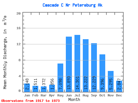
| Statistic | Jan | Feb | Mar | Apr | May | Jun | Jul | Aug | Sep | Oct | Nov | Dec | Annual |
|---|---|---|---|---|---|---|---|---|---|---|---|---|---|
| Mean | 2.15 | 1.51 | 1.37 | 1.86 | 7.10 | 13.89 | 14.30 | 13.22 | 12.23 | 9.40 | 5.29 | 2.85 | 7.02 |
| Standard Deviation | 1.93 | 1.18 | 1.02 | 1.27 | 1.97 | 2.27 | 2.16 | 2.98 | 3.58 | 3.45 | 2.91 | 2.03 | 0.72 |
| Min | 0.53 | 0.46 | 0.44 | 0.72 | 2.81 | 8.78 | 11.01 | 7.97 | 5.89 | 3.96 | 2.39 | 0.92 | 5.59 |
| Max | 11.46 | 5.63 | 5.29 | 7.70 | 10.34 | 20.44 | 18.69 | 19.15 | 20.25 | 17.36 | 18.61 | 9.80 | 8.38 |
| Coefficient of Variation | 0.90 | 0.78 | 0.74 | 0.68 | 0.28 | 0.16 | 0.15 | 0.23 | 0.29 | 0.37 | 0.55 | 0.71 | 0.10 |
 Return to R-Arctic Net Home Page