|
|
|||||||||||||||||
| Point ID: 9280 | Downloads | Plots | Site Data | Code: 15026000 |
|
|
|||||||||||||||||
| Download | |
|---|---|
| Site Descriptor Information | Site Time Series Data |
| Link to all available data | |
| View: | Time Series | All |
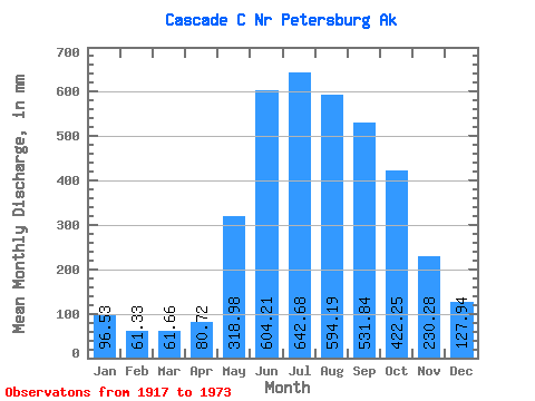
| Units: | m3/s |
| Statistic | Jan | Feb | Mar | Apr | May | Jun | Jul | Aug | Sep | Oct | Nov | Dec | Annual |
|---|---|---|---|---|---|---|---|---|---|---|---|---|---|
| Mean | 96.50 | 61.86 | 61.66 | 80.71 | 318.92 | 604.23 | 642.57 | 594.12 | 531.86 | 422.17 | 230.28 | 127.93 | 3715.24 |
| Standard Deviation | 86.82 | 48.30 | 45.83 | 55.13 | 88.33 | 98.59 | 96.99 | 133.93 | 155.75 | 154.98 | 126.49 | 91.13 | 383.63 |
| Min | 23.69 | 18.80 | 19.82 | 31.16 | 126.49 | 381.76 | 494.71 | 358.11 | 256.31 | 177.84 | 104.06 | 41.26 | 2962.77 |
| Max | 515.10 | 230.32 | 237.65 | 335.05 | 464.41 | 888.77 | 839.66 | 860.61 | 880.51 | 780.08 | 809.18 | 440.27 | 4434.61 |
| Coefficient of Variation | 0.90 | 0.78 | 0.74 | 0.68 | 0.28 | 0.16 | 0.15 | 0.23 | 0.29 | 0.37 | 0.55 | 0.71 | 0.10 |
 Return to R-Arctic Net Home Page