|
|
|||||||||||||||||
| Point ID: 9256 | Downloads | Plots | Site Data | Code: 15052800 |
|
|
|||||||||||||||||
| Download | |
|---|---|
| Site Descriptor Information | Site Time Series Data |
| Link to all available data | |
| View: | Time Series | All |
| Units: | mm |
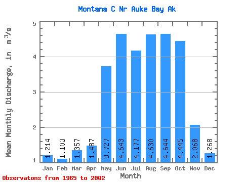
| Statistic | Jan | Feb | Mar | Apr | May | Jun | Jul | Aug | Sep | Oct | Nov | Dec | Annual |
|---|---|---|---|---|---|---|---|---|---|---|---|---|---|
| Mean | 1.21 | 1.10 | 1.36 | 1.49 | 3.73 | 4.64 | 4.18 | 4.63 | 4.64 | 4.45 | 2.07 | 1.27 | 2.92 |
| Standard Deviation | 1.28 | 0.84 | 1.31 | 0.52 | 1.05 | 1.10 | 1.16 | 1.49 | 1.69 | 1.57 | 1.05 | 0.89 | 0.43 |
| Min | 0.14 | 0.21 | 0.27 | 0.71 | 2.06 | 2.01 | 1.49 | 1.96 | 2.01 | 2.54 | 0.60 | 0.45 | 2.13 |
| Max | 5.28 | 3.42 | 5.52 | 2.51 | 5.23 | 5.85 | 6.03 | 6.98 | 7.46 | 8.07 | 3.91 | 3.16 | 3.47 |
| Coefficient of Variation | 1.06 | 0.76 | 0.97 | 0.35 | 0.28 | 0.24 | 0.28 | 0.32 | 0.36 | 0.35 | 0.51 | 0.70 | 0.15 |
 Return to R-Arctic Net Home Page