|
|
|||||||||||||||||
| Point ID: 9256 | Downloads | Plots | Site Data | Code: 15052800 |
|
|
|||||||||||||||||
| Download | |
|---|---|
| Site Descriptor Information | Site Time Series Data |
| Link to all available data | |
| View: | Time Series | All |
| Units: | m3/s |
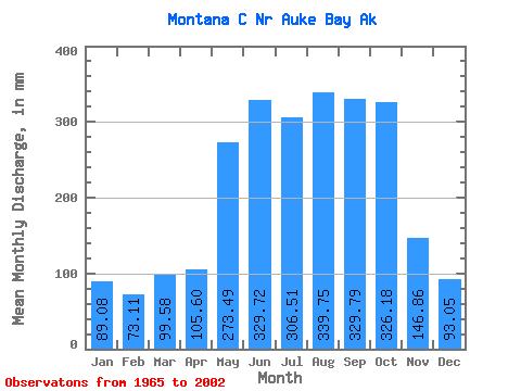
| Statistic | Jan | Feb | Mar | Apr | May | Jun | Jul | Aug | Sep | Oct | Nov | Dec | Annual |
|---|---|---|---|---|---|---|---|---|---|---|---|---|---|
| Mean | 89.09 | 73.71 | 99.57 | 105.59 | 273.43 | 329.71 | 306.48 | 339.67 | 329.81 | 326.16 | 146.82 | 93.03 | 2528.87 |
| Standard Deviation | 94.22 | 55.92 | 96.15 | 37.24 | 76.81 | 78.21 | 84.72 | 109.25 | 120.38 | 115.07 | 74.58 | 65.08 | 368.86 |
| Min | 10.42 | 14.25 | 20.04 | 50.30 | 150.79 | 142.91 | 109.10 | 143.75 | 142.56 | 186.45 | 42.96 | 33.11 | 1837.86 |
| Max | 387.44 | 228.45 | 405.21 | 178.03 | 383.62 | 415.58 | 442.57 | 511.90 | 529.53 | 591.78 | 277.50 | 231.68 | 2999.44 |
| Coefficient of Variation | 1.06 | 0.76 | 0.97 | 0.35 | 0.28 | 0.24 | 0.28 | 0.32 | 0.36 | 0.35 | 0.51 | 0.70 | 0.15 |
 Return to R-Arctic Net Home Page