|
|
|||||||||||||||||
| Point ID: 9255 | Downloads | Plots | Site Data | Code: 15052500 |
|
|
|||||||||||||||||
| Download | |
|---|---|
| Site Descriptor Information | Site Time Series Data |
| Link to all available data | |
| View: | Time Series | All |
| Units: | mm |
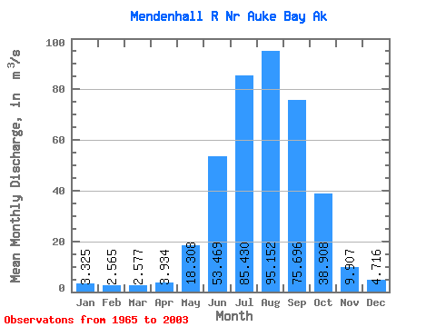
| Statistic | Jan | Feb | Mar | Apr | May | Jun | Jul | Aug | Sep | Oct | Nov | Dec | Annual |
|---|---|---|---|---|---|---|---|---|---|---|---|---|---|
| Mean | 3.33 | 2.56 | 2.58 | 3.93 | 18.31 | 53.47 | 85.43 | 95.15 | 75.70 | 38.91 | 9.91 | 4.72 | 32.87 |
| Standard Deviation | 3.01 | 1.65 | 2.23 | 1.89 | 7.20 | 12.62 | 12.82 | 17.35 | 20.94 | 17.30 | 5.99 | 3.82 | 4.35 |
| Min | 0.87 | 0.61 | 0.63 | 1.33 | 7.60 | 20.74 | 54.92 | 57.35 | 39.09 | 15.06 | 3.13 | 1.13 | 21.40 |
| Max | 16.98 | 7.20 | 10.73 | 8.87 | 34.75 | 79.83 | 108.61 | 133.11 | 116.11 | 75.00 | 26.07 | 15.95 | 40.17 |
| Coefficient of Variation | 0.91 | 0.64 | 0.87 | 0.48 | 0.39 | 0.24 | 0.15 | 0.18 | 0.28 | 0.45 | 0.60 | 0.81 | 0.13 |
 Return to R-Arctic Net Home Page