|
|
|||||||||||||||||
| Point ID: 9255 | Downloads | Plots | Site Data | Code: 15052500 |
|
|
|||||||||||||||||
| Download | |
|---|---|
| Site Descriptor Information | Site Time Series Data |
| Link to all available data | |
| View: | Time Series | All |
| Units: | m3/s |
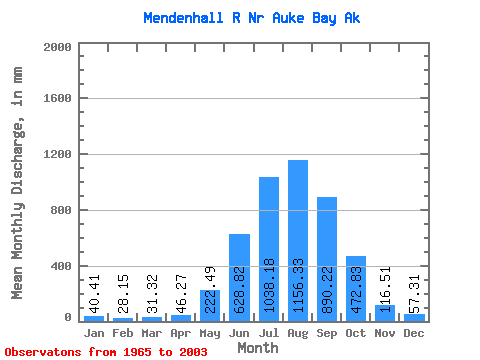
| Statistic | Jan | Feb | Mar | Apr | May | Jun | Jul | Aug | Sep | Oct | Nov | Dec | Annual |
|---|---|---|---|---|---|---|---|---|---|---|---|---|---|
| Mean | 40.41 | 28.39 | 31.31 | 46.27 | 222.45 | 628.82 | 1038.03 | 1156.16 | 890.22 | 472.76 | 116.51 | 57.30 | 4706.22 |
| Standard Deviation | 36.61 | 18.23 | 27.13 | 22.18 | 87.50 | 148.41 | 155.82 | 210.76 | 246.30 | 210.20 | 70.50 | 46.38 | 622.64 |
| Min | 10.61 | 6.75 | 7.67 | 15.62 | 92.38 | 243.94 | 667.26 | 696.79 | 459.70 | 183.04 | 36.80 | 13.78 | 3063.86 |
| Max | 206.28 | 79.74 | 130.32 | 104.27 | 422.21 | 938.78 | 1319.67 | 1617.34 | 1365.48 | 911.28 | 306.53 | 193.80 | 5752.28 |
| Coefficient of Variation | 0.91 | 0.64 | 0.87 | 0.48 | 0.39 | 0.24 | 0.15 | 0.18 | 0.28 | 0.45 | 0.60 | 0.81 | 0.13 |
 Return to R-Arctic Net Home Page