|
|
|||||||||||||||||
| Point ID: 9248 | Downloads | Plots | Site Data | Code: 15050000 |
|
|
|||||||||||||||||
| Download | |
|---|---|
| Site Descriptor Information | Site Time Series Data |
| Link to all available data | |
| View: | Time Series | All |
| Units: | mm |
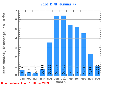
| Statistic | Jan | Feb | Mar | Apr | May | Jun | Jul | Aug | Sep | Oct | Nov | Dec | Annual |
|---|---|---|---|---|---|---|---|---|---|---|---|---|---|
| Mean | 0.64 | 0.41 | 0.35 | 0.69 | 3.54 | 6.36 | 6.40 | 5.40 | 5.24 | 4.52 | 2.33 | 1.06 | 3.09 |
| Standard Deviation | 0.77 | 0.48 | 0.62 | 0.49 | 1.03 | 1.18 | 1.56 | 1.99 | 1.75 | 1.82 | 1.39 | 1.02 | 0.45 |
| Min | 0.05 | 0.01 | 0.00 | 0.11 | 1.82 | 3.43 | 3.13 | 2.42 | 2.09 | 1.77 | 0.51 | 0.18 | 2.06 |
| Max | 4.82 | 2.31 | 3.89 | 2.60 | 6.23 | 9.23 | 10.30 | 10.60 | 8.56 | 9.89 | 5.83 | 5.73 | 4.25 |
| Coefficient of Variation | 1.19 | 1.17 | 1.78 | 0.70 | 0.29 | 0.18 | 0.24 | 0.37 | 0.33 | 0.40 | 0.60 | 0.96 | 0.15 |
 Return to R-Arctic Net Home Page