|
|
|||||||||||||||||
| Point ID: 9248 | Downloads | Plots | Site Data | Code: 15050000 |
|
|
|||||||||||||||||
| Download | |
|---|---|
| Site Descriptor Information | Site Time Series Data |
| Link to all available data | |
| View: | Time Series | All |
| Units: | m3/s |
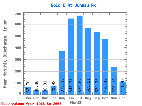
| Statistic | Jan | Feb | Mar | Apr | May | Jun | Jul | Aug | Sep | Oct | Nov | Dec | Annual |
|---|---|---|---|---|---|---|---|---|---|---|---|---|---|
| Mean | 67.66 | 39.20 | 36.85 | 70.94 | 373.17 | 648.73 | 674.79 | 569.18 | 534.73 | 476.30 | 238.22 | 111.40 | 3844.58 |
| Standard Deviation | 80.67 | 45.88 | 65.56 | 49.92 | 108.14 | 119.92 | 164.38 | 209.71 | 178.19 | 192.24 | 142.23 | 107.53 | 564.27 |
| Min | 5.09 | 1.30 | 0.17 | 10.95 | 192.41 | 350.41 | 330.11 | 254.82 | 213.06 | 186.84 | 52.40 | 18.60 | 2555.85 |
| Max | 508.31 | 221.41 | 410.37 | 265.08 | 656.81 | 942.32 | 1086.07 | 1117.17 | 873.64 | 1042.63 | 594.70 | 603.75 | 5283.36 |
| Coefficient of Variation | 1.19 | 1.17 | 1.78 | 0.70 | 0.29 | 0.18 | 0.24 | 0.37 | 0.33 | 0.40 | 0.60 | 0.96 | 0.15 |
 Return to R-Arctic Net Home Page