|
|
|||||||||||||||||
| Point ID: 9246 | Downloads | Plots | Site Data | Code: 15048000 |
|
|
|||||||||||||||||
| Download | |
|---|---|
| Site Descriptor Information | Site Time Series Data |
| Link to all available data | |
| View: | Time Series | All |
| Units: | mm |
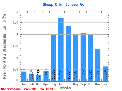
| Statistic | Jan | Feb | Mar | Apr | May | Jun | Jul | Aug | Sep | Oct | Nov | Dec | Annual |
|---|---|---|---|---|---|---|---|---|---|---|---|---|---|
| Mean | 0.42 | 0.29 | 0.26 | 0.45 | 1.96 | 2.70 | 2.36 | 2.03 | 2.05 | 2.02 | 1.38 | 0.63 | 1.38 |
| Standard Deviation | 0.32 | 0.28 | 0.28 | 0.28 | 0.44 | 0.70 | 0.64 | 0.68 | 0.69 | 0.61 | 0.65 | 0.40 | 0.24 |
| Min | 0.02 | 0.00 | 0.00 | 0.00 | 1.13 | 1.70 | 1.26 | 0.76 | 0.97 | 0.85 | 0.52 | 0.13 | 0.86 |
| Max | 1.51 | 1.23 | 1.13 | 1.21 | 2.68 | 5.46 | 4.06 | 3.73 | 3.83 | 3.19 | 3.03 | 1.50 | 1.82 |
| Coefficient of Variation | 0.76 | 0.94 | 1.07 | 0.63 | 0.23 | 0.26 | 0.27 | 0.33 | 0.34 | 0.30 | 0.47 | 0.63 | 0.17 |
 Return to R-Arctic Net Home Page