|
|
|||||||||||||||||
| Point ID: 9246 | Downloads | Plots | Site Data | Code: 15048000 |
|
|
|||||||||||||||||
| Download | |
|---|---|
| Site Descriptor Information | Site Time Series Data |
| Link to all available data | |
| View: | Time Series | All |
| Units: | m3/s |
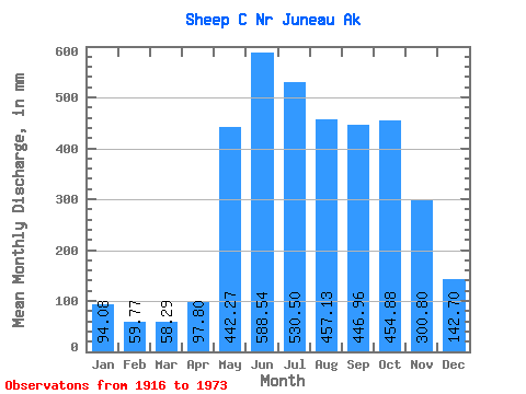
| Statistic | Jan | Feb | Mar | Apr | May | Jun | Jul | Aug | Sep | Oct | Nov | Dec | Annual |
|---|---|---|---|---|---|---|---|---|---|---|---|---|---|
| Mean | 94.07 | 60.22 | 58.35 | 97.72 | 442.23 | 588.57 | 530.34 | 457.16 | 446.91 | 454.81 | 300.70 | 142.58 | 3670.16 |
| Standard Deviation | 71.34 | 56.54 | 62.21 | 61.96 | 99.42 | 152.44 | 144.15 | 152.06 | 149.66 | 137.38 | 142.28 | 90.22 | 631.15 |
| Min | 4.98 | 0.32 | 0.00 | 0.55 | 253.83 | 370.90 | 282.88 | 171.68 | 210.53 | 191.39 | 113.40 | 28.88 | 2281.31 |
| Max | 339.99 | 252.78 | 253.69 | 262.77 | 602.91 | 1189.36 | 913.90 | 840.33 | 835.11 | 717.63 | 660.39 | 337.32 | 4832.21 |
| Coefficient of Variation | 0.76 | 0.94 | 1.07 | 0.63 | 0.23 | 0.26 | 0.27 | 0.33 | 0.34 | 0.30 | 0.47 | 0.63 | 0.17 |
 Return to R-Arctic Net Home Page