|
|
|||||||||||||||||
| Point ID: 9237 | Downloads | Plots | Site Data | Code: 15051008 |
|
|
|||||||||||||||||
| Download | |
|---|---|
| Site Descriptor Information | Site Time Series Data |
| Link to all available data | |
| View: | Time Series | All |
| Units: | mm |
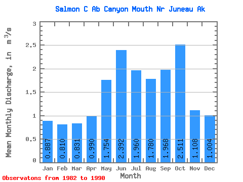
| Statistic | Jan | Feb | Mar | Apr | May | Jun | Jul | Aug | Sep | Oct | Nov | Dec | Annual |
|---|---|---|---|---|---|---|---|---|---|---|---|---|---|
| Mean | 0.89 | 0.81 | 0.83 | 0.99 | 1.75 | 2.39 | 1.96 | 1.78 | 1.97 | 2.51 | 1.11 | 1.00 | 1.51 |
| Standard Deviation | 0.56 | 0.69 | 0.74 | 0.82 | 0.67 | 0.70 | 0.84 | 0.93 | 1.07 | 0.89 | 0.41 | 0.31 | 0.58 |
| Min | 0.35 | 0.18 | 0.16 | 0.36 | 0.95 | 1.56 | 1.04 | 0.71 | 0.58 | 1.25 | 0.33 | 0.64 | 1.02 |
| Max | 1.76 | 1.99 | 2.10 | 2.57 | 3.11 | 3.29 | 3.33 | 3.24 | 4.23 | 3.76 | 1.52 | 1.57 | 2.44 |
| Coefficient of Variation | 0.64 | 0.85 | 0.89 | 0.83 | 0.38 | 0.29 | 0.43 | 0.52 | 0.55 | 0.36 | 0.37 | 0.31 | 0.39 |
 Return to R-Arctic Net Home Page