|
|
|||||||||||||||||
| Point ID: 9237 | Downloads | Plots | Site Data | Code: 15051008 |
|
|
|||||||||||||||||
| Download | |
|---|---|
| Site Descriptor Information | Site Time Series Data |
| Link to all available data | |
| View: | Time Series | All |
| Units: | m3/s |
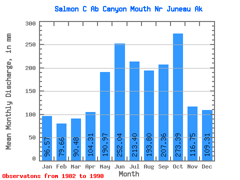
| Statistic | Jan | Feb | Mar | Apr | May | Jun | Jul | Aug | Sep | Oct | Nov | Dec | Annual |
|---|---|---|---|---|---|---|---|---|---|---|---|---|---|
| Mean | 96.60 | 80.30 | 90.47 | 104.27 | 190.99 | 252.03 | 213.33 | 193.75 | 207.33 | 273.36 | 116.71 | 109.31 | 1933.26 |
| Standard Deviation | 61.32 | 67.91 | 80.26 | 86.89 | 72.54 | 74.08 | 91.04 | 100.74 | 113.05 | 97.29 | 42.92 | 33.84 | 746.14 |
| Min | 38.25 | 17.77 | 17.28 | 38.32 | 103.91 | 164.50 | 112.78 | 77.07 | 61.16 | 136.04 | 34.30 | 69.90 | 1307.90 |
| Max | 191.82 | 197.80 | 229.20 | 270.92 | 338.50 | 347.09 | 362.40 | 352.41 | 445.25 | 409.80 | 160.41 | 170.74 | 3135.92 |
| Coefficient of Variation | 0.64 | 0.85 | 0.89 | 0.83 | 0.38 | 0.29 | 0.43 | 0.52 | 0.55 | 0.36 | 0.37 | 0.31 | 0.39 |
 Return to R-Arctic Net Home Page