|
|
|||||||||||||||||
| Point ID: 9225 | Downloads | Plots | Site Data | Code: 15195000 |
|
|
|||||||||||||||||
| Download | |
|---|---|
| Site Descriptor Information | Site Time Series Data |
| Link to all available data | |
| View: | Time Series | All |
| Units: | mm |
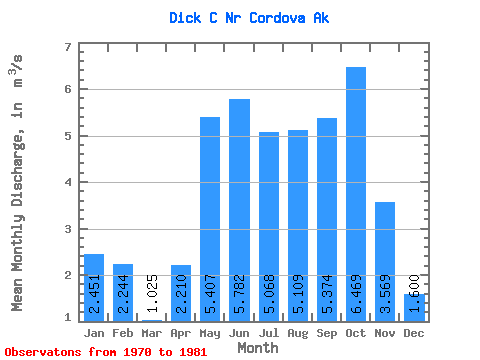
| Statistic | Jan | Feb | Mar | Apr | May | Jun | Jul | Aug | Sep | Oct | Nov | Dec | Annual |
|---|---|---|---|---|---|---|---|---|---|---|---|---|---|
| Mean | 2.45 | 2.24 | 1.02 | 2.21 | 5.41 | 5.78 | 5.07 | 5.11 | 5.37 | 6.47 | 3.57 | 1.60 | 3.74 |
| Standard Deviation | 3.39 | 3.55 | 1.30 | 1.47 | 1.82 | 1.35 | 1.34 | 2.72 | 1.67 | 2.02 | 3.99 | 1.72 | 0.80 |
| Min | 0.20 | 0.18 | 0.13 | 0.19 | 2.03 | 2.87 | 2.82 | 2.57 | 3.31 | 3.51 | 0.36 | 0.52 | 2.75 |
| Max | 9.53 | 11.86 | 4.11 | 5.18 | 8.04 | 8.82 | 6.94 | 12.97 | 7.91 | 9.39 | 14.53 | 6.37 | 5.19 |
| Coefficient of Variation | 1.38 | 1.58 | 1.27 | 0.67 | 0.34 | 0.23 | 0.27 | 0.53 | 0.31 | 0.31 | 1.12 | 1.07 | 0.21 |
 Return to R-Arctic Net Home Page