|
|
|||||||||||||||||
| Point ID: 9225 | Downloads | Plots | Site Data | Code: 15195000 |
|
|
|||||||||||||||||
| Download | |
|---|---|
| Site Descriptor Information | Site Time Series Data |
| Link to all available data | |
| View: | Time Series | All |
| Units: | m3/s |
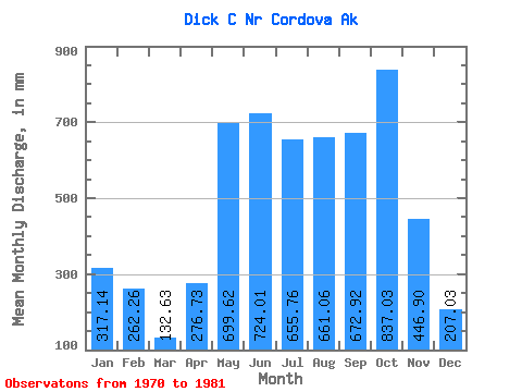
| Statistic | Jan | Feb | Mar | Apr | May | Jun | Jul | Aug | Sep | Oct | Nov | Dec | Annual |
|---|---|---|---|---|---|---|---|---|---|---|---|---|---|
| Mean | 317.11 | 264.54 | 132.64 | 276.71 | 699.55 | 723.98 | 655.71 | 660.97 | 672.88 | 836.91 | 446.91 | 206.95 | 5695.85 |
| Standard Deviation | 439.01 | 418.40 | 168.11 | 184.06 | 235.92 | 168.93 | 173.54 | 351.39 | 209.01 | 260.86 | 499.32 | 222.39 | 1217.79 |
| Min | 26.50 | 20.78 | 16.77 | 23.67 | 262.12 | 358.83 | 364.31 | 331.95 | 414.97 | 454.63 | 45.45 | 67.04 | 4185.84 |
| Max | 1233.27 | 1398.19 | 531.79 | 649.10 | 1039.93 | 1104.51 | 897.97 | 1677.73 | 990.09 | 1214.36 | 1818.86 | 823.56 | 7908.67 |
| Coefficient of Variation | 1.38 | 1.58 | 1.27 | 0.67 | 0.34 | 0.23 | 0.27 | 0.53 | 0.31 | 0.31 | 1.12 | 1.07 | 0.21 |
 Return to R-Arctic Net Home Page