|
|
|||||||||||||||||
| Point ID: 9217 | Downloads | Plots | Site Data | Code: 15206000 |
|
|
|||||||||||||||||
| Download | |
|---|---|
| Site Descriptor Information | Site Time Series Data |
| Link to all available data | |
| View: | Time Series | All |
| Units: | mm |
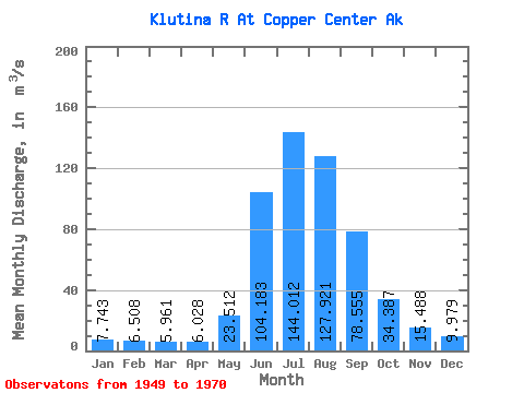
| Statistic | Jan | Feb | Mar | Apr | May | Jun | Jul | Aug | Sep | Oct | Nov | Dec | Annual |
|---|---|---|---|---|---|---|---|---|---|---|---|---|---|
| Mean | 7.74 | 6.51 | 5.96 | 6.03 | 23.51 | 104.18 | 144.01 | 127.92 | 78.56 | 34.39 | 15.49 | 9.98 | 47.36 |
| Standard Deviation | 2.39 | 2.02 | 1.32 | 1.52 | 9.38 | 34.78 | 20.21 | 17.44 | 29.06 | 10.58 | 5.63 | 3.29 | 6.38 |
| Min | 4.53 | 3.83 | 3.68 | 3.12 | 7.49 | 56.79 | 114.12 | 98.79 | 48.70 | 20.52 | 6.42 | 5.52 | 37.36 |
| Max | 14.16 | 11.33 | 8.49 | 8.21 | 43.95 | 168.22 | 200.24 | 163.29 | 151.84 | 59.16 | 30.54 | 20.11 | 63.16 |
| Coefficient of Variation | 0.31 | 0.31 | 0.22 | 0.25 | 0.40 | 0.33 | 0.14 | 0.14 | 0.37 | 0.31 | 0.36 | 0.33 | 0.14 |
 Return to R-Arctic Net Home Page