|
|
|||||||||||||||||
| Point ID: 9217 | Downloads | Plots | Site Data | Code: 15206000 |
|
|
|||||||||||||||||
| Download | |
|---|---|
| Site Descriptor Information | Site Time Series Data |
| Link to all available data | |
| View: | Time Series | All |
| Units: | m3/s |
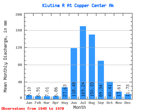
| Statistic | Jan | Feb | Mar | Apr | May | Jun | Jul | Aug | Sep | Oct | Nov | Dec | Annual |
|---|---|---|---|---|---|---|---|---|---|---|---|---|---|
| Mean | 9.10 | 6.97 | 7.00 | 6.86 | 27.63 | 118.48 | 169.21 | 150.30 | 89.34 | 40.40 | 17.61 | 11.72 | 655.84 |
| Standard Deviation | 2.81 | 2.16 | 1.55 | 1.73 | 11.02 | 39.56 | 23.75 | 20.49 | 33.05 | 12.43 | 6.41 | 3.86 | 88.31 |
| Min | 5.32 | 4.10 | 4.33 | 3.54 | 8.80 | 64.59 | 134.08 | 116.08 | 55.38 | 24.11 | 7.30 | 6.48 | 517.31 |
| Max | 16.64 | 12.13 | 9.98 | 9.34 | 51.64 | 191.31 | 235.27 | 191.86 | 172.68 | 69.52 | 34.73 | 23.62 | 874.63 |
| Coefficient of Variation | 0.31 | 0.31 | 0.22 | 0.25 | 0.40 | 0.33 | 0.14 | 0.14 | 0.37 | 0.31 | 0.36 | 0.33 | 0.14 |
 Return to R-Arctic Net Home Page