|
|
|||||||||||||||||
| Point ID: 9198 | Downloads | Plots | Site Data | Code: 15237360 |
|
|
|||||||||||||||||
| Download | |
|---|---|
| Site Descriptor Information | Site Time Series Data |
| Link to all available data | |
| View: | Time Series | All |
| Units: | mm |
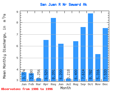
| Statistic | Jan | Feb | Mar | Apr | May | Jun | Jul | Aug | Sep | Oct | Nov | Dec | Annual |
|---|---|---|---|---|---|---|---|---|---|---|---|---|---|
| Mean | 3.77 | 3.68 | 3.26 | 6.52 | 8.39 | 6.20 | 3.22 | 6.40 | 7.61 | 8.78 | 5.32 | 7.53 | 6.09 |
| Standard Deviation | 3.15 | 3.13 | 1.88 | 2.03 | 3.97 | 4.37 | 1.45 | 3.81 | 3.69 | 3.43 | 2.64 | 5.12 | 1.28 |
| Min | 0.73 | 0.50 | 0.69 | 3.61 | 3.15 | 2.08 | 1.32 | 1.08 | 3.09 | 4.42 | 0.38 | 0.26 | 3.91 |
| Max | 10.32 | 10.56 | 5.60 | 9.27 | 16.38 | 17.81 | 5.40 | 12.28 | 13.65 | 15.28 | 8.61 | 16.85 | 7.59 |
| Coefficient of Variation | 0.83 | 0.85 | 0.58 | 0.31 | 0.47 | 0.70 | 0.45 | 0.59 | 0.48 | 0.39 | 0.50 | 0.68 | 0.21 |
 Return to R-Arctic Net Home Page