|
|
|||||||||||||||||
| Point ID: 9198 | Downloads | Plots | Site Data | Code: 15237360 |
|
|
|||||||||||||||||
| Download | |
|---|---|
| Site Descriptor Information | Site Time Series Data |
| Link to all available data | |
| View: | Time Series | All |
| Units: | m3/s |
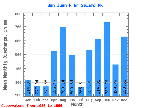
| Statistic | Jan | Feb | Mar | Apr | May | Jun | Jul | Aug | Sep | Oct | Nov | Dec | Annual |
|---|---|---|---|---|---|---|---|---|---|---|---|---|---|
| Mean | 314.84 | 279.73 | 271.60 | 526.51 | 700.06 | 500.64 | 268.44 | 533.95 | 614.84 | 732.69 | 429.24 | 628.48 | 5984.41 |
| Standard Deviation | 262.81 | 238.30 | 156.74 | 163.74 | 331.08 | 352.70 | 120.80 | 317.66 | 297.65 | 285.98 | 212.97 | 427.56 | 1258.98 |
| Min | 61.19 | 37.97 | 57.30 | 291.44 | 262.53 | 168.21 | 109.96 | 90.14 | 249.46 | 368.83 | 30.45 | 21.61 | 3841.38 |
| Max | 860.75 | 802.46 | 467.06 | 748.84 | 1366.14 | 1437.76 | 450.34 | 1024.21 | 1102.10 | 1274.39 | 695.33 | 1405.70 | 7460.09 |
| Coefficient of Variation | 0.83 | 0.85 | 0.58 | 0.31 | 0.47 | 0.70 | 0.45 | 0.59 | 0.48 | 0.39 | 0.50 | 0.68 | 0.21 |
 Return to R-Arctic Net Home Page