|
|
|||||||||||||||||
| Point ID: 9194 | Downloads | Plots | Site Data | Code: 15236000 |
|
|
|||||||||||||||||
| Download | |
|---|---|
| Site Descriptor Information | Site Time Series Data |
| Link to all available data | |
| View: | Time Series | All |
| Units: | mm |
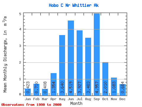
| Statistic | Jan | Feb | Mar | Apr | May | Jun | Jul | Aug | Sep | Oct | Nov | Dec | Annual |
|---|---|---|---|---|---|---|---|---|---|---|---|---|---|
| Mean | 0.42 | 0.71 | 0.41 | 1.35 | 3.64 | 4.52 | 3.93 | 3.48 | 4.96 | 2.01 | 1.08 | 0.68 | 2.31 |
| Standard Deviation | 0.18 | 0.46 | 0.22 | 0.43 | 1.00 | 1.08 | 1.38 | 1.00 | 4.39 | 0.62 | 0.74 | 0.41 | 0.66 |
| Min | 0.24 | 0.21 | 0.16 | 0.63 | 2.35 | 2.32 | 2.01 | 2.02 | 1.41 | 1.02 | 0.26 | 0.21 | 1.46 |
| Max | 0.74 | 1.43 | 0.87 | 2.01 | 5.34 | 5.91 | 6.49 | 4.74 | 16.75 | 2.90 | 2.41 | 1.43 | 3.75 |
| Coefficient of Variation | 0.44 | 0.64 | 0.55 | 0.32 | 0.27 | 0.24 | 0.35 | 0.29 | 0.89 | 0.31 | 0.68 | 0.60 | 0.29 |
 Return to R-Arctic Net Home Page