|
|
|||||||||||||||||
| Point ID: 9194 | Downloads | Plots | Site Data | Code: 15236000 |
|
|
|||||||||||||||||
| Download | |
|---|---|
| Site Descriptor Information | Site Time Series Data |
| Link to all available data | |
| View: | Time Series | All |
| Units: | m3/s |
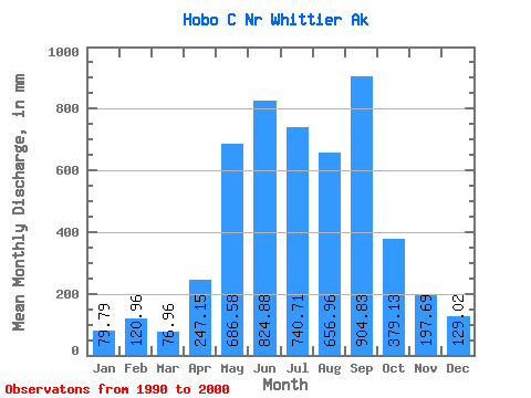
| Statistic | Jan | Feb | Mar | Apr | May | Jun | Jul | Aug | Sep | Oct | Nov | Dec | Annual |
|---|---|---|---|---|---|---|---|---|---|---|---|---|---|
| Mean | 79.75 | 121.96 | 76.86 | 247.10 | 686.41 | 824.95 | 740.64 | 656.92 | 904.75 | 379.07 | 197.71 | 128.98 | 5135.39 |
| Standard Deviation | 34.88 | 78.48 | 41.86 | 77.79 | 187.98 | 197.34 | 261.00 | 188.14 | 801.66 | 116.37 | 134.37 | 77.71 | 1470.36 |
| Min | 46.05 | 36.51 | 30.63 | 114.61 | 443.94 | 422.99 | 378.88 | 380.89 | 257.94 | 192.24 | 47.09 | 39.62 | 3245.11 |
| Max | 140.30 | 245.72 | 164.48 | 366.11 | 1006.92 | 1078.73 | 1223.02 | 893.72 | 3058.05 | 546.42 | 440.38 | 269.07 | 8326.34 |
| Coefficient of Variation | 0.44 | 0.64 | 0.55 | 0.32 | 0.27 | 0.24 | 0.35 | 0.29 | 0.89 | 0.31 | 0.68 | 0.60 | 0.29 |
 Return to R-Arctic Net Home Page