|
|
|||||||||||||||||
| Point ID: 9149 | Downloads | Plots | Site Data | Code: 15101490 |
|
|
|||||||||||||||||
| Download | |
|---|---|
| Site Descriptor Information | Site Time Series Data |
| Link to all available data | |
| View: | Time Series | All |
| Units: | mm |
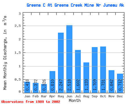
| Statistic | Jan | Feb | Mar | Apr | May | Jun | Jul | Aug | Sep | Oct | Nov | Dec | Annual |
|---|---|---|---|---|---|---|---|---|---|---|---|---|---|
| Mean | 0.42 | 0.37 | 0.33 | 0.81 | 2.25 | 2.52 | 1.60 | 1.13 | 1.71 | 1.73 | 0.84 | 0.71 | 1.21 |
| Standard Deviation | 0.16 | 0.25 | 0.19 | 0.38 | 0.50 | 0.65 | 0.51 | 0.46 | 0.51 | 0.49 | 0.32 | 0.49 | 0.19 |
| Min | 0.16 | 0.10 | 0.08 | 0.10 | 1.60 | 1.69 | 0.89 | 0.42 | 0.94 | 0.98 | 0.41 | 0.23 | 0.96 |
| Max | 0.63 | 1.04 | 0.77 | 1.41 | 3.03 | 4.16 | 2.56 | 1.97 | 2.69 | 2.77 | 1.40 | 1.86 | 1.60 |
| Coefficient of Variation | 0.39 | 0.68 | 0.59 | 0.47 | 0.22 | 0.26 | 0.32 | 0.41 | 0.30 | 0.29 | 0.38 | 0.69 | 0.16 |
 Return to R-Arctic Net Home Page