|
|
|||||||||||||||||
| Point ID: 9149 | Downloads | Plots | Site Data | Code: 15101490 |
|
|
|||||||||||||||||
| Download | |
|---|---|
| Site Descriptor Information | Site Time Series Data |
| Link to all available data | |
| View: | Time Series | All |
| Units: | m3/s |
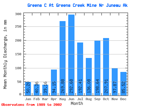
| Statistic | Jan | Feb | Mar | Apr | May | Jun | Jul | Aug | Sep | Oct | Nov | Dec | Annual |
|---|---|---|---|---|---|---|---|---|---|---|---|---|---|
| Mean | 50.19 | 40.68 | 39.10 | 94.14 | 269.86 | 292.68 | 192.42 | 136.04 | 198.67 | 207.86 | 97.82 | 85.49 | 1706.36 |
| Standard Deviation | 19.64 | 27.66 | 22.93 | 44.34 | 59.74 | 75.27 | 60.59 | 55.60 | 59.66 | 59.40 | 36.64 | 58.56 | 272.53 |
| Min | 18.69 | 10.60 | 9.56 | 11.73 | 191.86 | 195.83 | 107.00 | 50.26 | 109.50 | 117.91 | 47.91 | 28.11 | 1353.67 |
| Max | 75.99 | 114.32 | 92.58 | 163.35 | 363.41 | 483.05 | 307.55 | 237.06 | 312.79 | 332.92 | 162.92 | 223.34 | 2258.93 |
| Coefficient of Variation | 0.39 | 0.68 | 0.59 | 0.47 | 0.22 | 0.26 | 0.32 | 0.41 | 0.30 | 0.29 | 0.38 | 0.69 | 0.16 |
 Return to R-Arctic Net Home Page