|
|
|||||||||||||||||
| Point ID: 9121 | Downloads | Plots | Site Data | Code: 05AE043 |
|
|
|||||||||||||||||
| Download | |
|---|---|
| Site Descriptor Information | Site Time Series Data |
| Link to all available data | |
| View: | Time Series | All |
| Units: | mm |
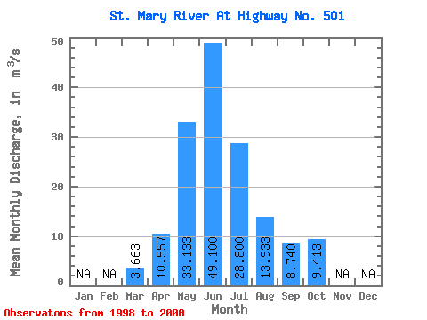
| Statistic | Jan | Feb | Mar | Apr | May | Jun | Jul | Aug | Sep | Oct | Nov | Dec | Annual |
|---|---|---|---|---|---|---|---|---|---|---|---|---|---|
| Mean | 3.66 | 10.56 | 33.13 | 49.10 | 28.80 | 13.93 | 8.74 | 9.41 | |||||
| Standard Deviation | 0.21 | 1.27 | 8.90 | 6.44 | 6.96 | 4.82 | 1.92 | 4.55 | |||||
| Min | 3.51 | 9.27 | 27.70 | 41.90 | 23.60 | 11.00 | 6.87 | 5.14 | |||||
| Max | 3.90 | 11.80 | 43.40 | 54.30 | 36.70 | 19.50 | 10.70 | 14.20 | |||||
| Coefficient of Variation | 0.06 | 0.12 | 0.27 | 0.13 | 0.24 | 0.35 | 0.22 | 0.48 |
 Return to R-Arctic Net Home Page