|
|
| Point ID: 9121 | Downloads | Plots | Site Data | Code: 05AE043 |
|
| Download | |
|---|---|
| Site Descriptor Information | Site Time Series Data |
| Link to all available data | |
|
|
|
| View: | Statistics | All |
| Units: | mm |
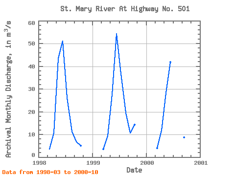
| Year | Jan | Feb | Mar | Apr | May | Jun | Jul | Aug | Sep | Oct | Nov | Dec | Annual | 1998 | 3.58 | 10.60 | 43.40 | 51.10 | 26.10 | 11.30 | 6.87 | 5.14 | 1999 | 3.51 | 9.27 | 27.70 | 54.30 | 36.70 | 19.50 | 10.70 | 14.20 | 2000 | 3.90 | 11.80 | 28.30 | 41.90 | 23.60 | 11.00 | 8.65 | 8.90 |
|---|
 Return to R-Arctic Net Home Page