|
|
|||||||||||||||||
| Point ID: 9106 | Downloads | Plots | Site Data | Code: 15388030 |
|
|
|||||||||||||||||
| Download | |
|---|---|
| Site Descriptor Information | Site Time Series Data |
| Link to all available data | |
| View: | Time Series | All |
| Units: | mm |
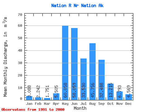
| Statistic | Jan | Feb | Mar | Apr | May | Jun | Jul | Aug | Sep | Oct | Nov | Dec | Annual |
|---|---|---|---|---|---|---|---|---|---|---|---|---|---|
| Mean | 3.09 | 2.24 | 1.75 | 5.50 | 60.06 | 58.06 | 33.53 | 45.76 | 32.49 | 13.21 | 6.79 | 4.57 | 19.63 |
| Standard Deviation | 1.54 | 1.34 | 1.10 | 5.92 | 22.12 | 45.24 | 18.52 | 21.04 | 10.52 | 4.45 | 1.13 | 1.35 | 11.13 |
| Min | 1.46 | 0.72 | 0.49 | 0.80 | 25.84 | 21.48 | 15.07 | 22.65 | 15.37 | 8.29 | 5.49 | 3.57 | 11.76 |
| Max | 4.53 | 3.23 | 2.48 | 14.15 | 88.99 | 169.36 | 74.72 | 87.87 | 50.41 | 20.92 | 7.50 | 6.10 | 27.50 |
| Coefficient of Variation | 0.50 | 0.60 | 0.63 | 1.08 | 0.37 | 0.78 | 0.55 | 0.46 | 0.32 | 0.34 | 0.17 | 0.29 | 0.57 |
 Return to R-Arctic Net Home Page