|
|
|||||||||||||||||
| Point ID: 9106 | Downloads | Plots | Site Data | Code: 15388030 |
|
|
|||||||||||||||||
| Download | |
|---|---|
| Site Descriptor Information | Site Time Series Data |
| Link to all available data | |
| View: | Time Series | All |
| Units: | m3/s |
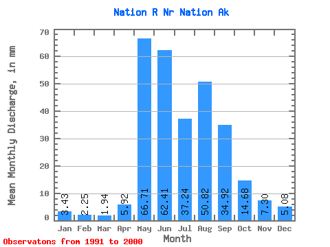
| Statistic | Jan | Feb | Mar | Apr | May | Jun | Jul | Aug | Sep | Oct | Nov | Dec | Annual |
|---|---|---|---|---|---|---|---|---|---|---|---|---|---|
| Mean | 3.43 | 2.27 | 1.94 | 5.92 | 66.70 | 62.41 | 37.24 | 50.82 | 34.92 | 14.68 | 7.30 | 5.08 | 256.94 |
| Standard Deviation | 1.71 | 1.35 | 1.22 | 6.37 | 24.56 | 48.63 | 20.57 | 23.37 | 11.30 | 4.95 | 1.21 | 1.50 | 145.71 |
| Min | 1.62 | 0.73 | 0.54 | 0.86 | 28.70 | 23.09 | 16.74 | 25.16 | 16.52 | 9.21 | 5.91 | 3.97 | 153.91 |
| Max | 5.03 | 3.27 | 2.75 | 15.21 | 98.83 | 182.06 | 82.98 | 97.59 | 54.19 | 23.23 | 8.07 | 6.78 | 359.97 |
| Coefficient of Variation | 0.50 | 0.60 | 0.63 | 1.08 | 0.37 | 0.78 | 0.55 | 0.46 | 0.32 | 0.34 | 0.17 | 0.29 | 0.57 |
 Return to R-Arctic Net Home Page