|
|
|||||||||||||||||
| Point ID: 9091 | Downloads | Plots | Site Data | Code: 151.28.0.1001.1 |
|
|
|||||||||||||||||
| Download | |
|---|---|
| Site Descriptor Information | Site Time Series Data |
| Link to all available data | |
| View: | Time Series | All |
| Units: | mm |
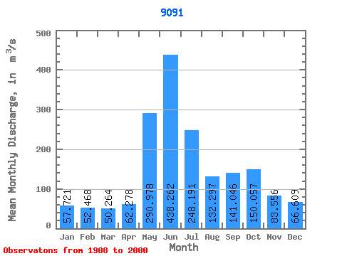
| Statistic | Jan | Feb | Mar | Apr | May | Jun | Jul | Aug | Sep | Oct | Nov | Dec | Annual |
|---|---|---|---|---|---|---|---|---|---|---|---|---|---|
| Mean | 57.72 | 52.47 | 50.26 | 62.28 | 290.98 | 438.26 | 248.19 | 132.30 | 141.05 | 150.06 | 83.56 | 66.61 | 147.92 |
| Standard Deviation | 42.97 | 38.30 | 42.45 | 30.14 | 112.00 | 121.43 | 101.19 | 50.59 | 58.64 | 66.82 | 50.14 | 37.97 | 26.70 |
| Min | 11.43 | 4.82 | 6.65 | 10.73 | 70.80 | 187.02 | 93.46 | 57.57 | 50.05 | 26.96 | 9.54 | 13.92 | 87.99 |
| Max | 223.65 | 218.11 | 250.30 | 146.78 | 504.24 | 729.67 | 550.90 | 302.52 | 332.66 | 343.08 | 247.44 | 192.73 | 220.26 |
| Coefficient of Variation | 0.74 | 0.73 | 0.84 | 0.48 | 0.39 | 0.28 | 0.41 | 0.38 | 0.42 | 0.45 | 0.60 | 0.57 | 0.18 |
 Return to R-Arctic Net Home Page