|
|
|||||||||||||||||
| Point ID: 9091 | Downloads | Plots | Site Data | Code: 151.28.0.1001.1 |
|
|
|||||||||||||||||
| Download | |
|---|---|
| Site Descriptor Information | Site Time Series Data |
| Link to all available data | |
| View: | Time Series | All |
| Units: | m3/s |
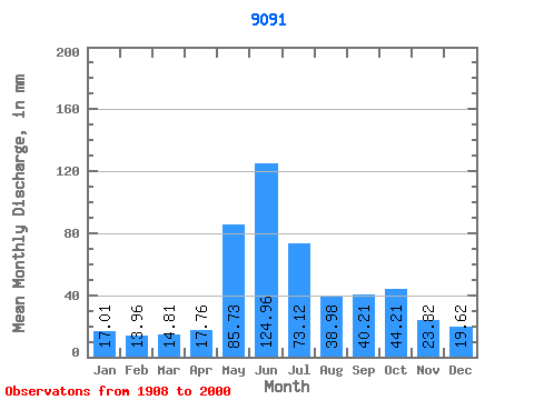
| Statistic | Jan | Feb | Mar | Apr | May | Jun | Jul | Aug | Sep | Oct | Nov | Dec | Annual |
|---|---|---|---|---|---|---|---|---|---|---|---|---|---|
| Mean | 42.51 | 35.21 | 37.02 | 44.40 | 214.31 | 312.42 | 182.80 | 97.44 | 100.55 | 110.52 | 59.56 | 49.06 | 1283.94 |
| Standard Deviation | 31.65 | 25.71 | 31.26 | 21.49 | 82.49 | 86.56 | 74.52 | 37.26 | 41.80 | 49.21 | 35.74 | 27.97 | 231.73 |
| Min | 8.42 | 3.24 | 4.90 | 7.65 | 52.14 | 133.32 | 68.84 | 42.40 | 35.68 | 19.86 | 6.80 | 10.25 | 763.77 |
| Max | 164.72 | 146.36 | 184.35 | 104.64 | 371.38 | 520.16 | 405.75 | 222.81 | 237.15 | 252.69 | 176.40 | 141.95 | 1911.82 |
| Coefficient of Variation | 0.74 | 0.73 | 0.84 | 0.48 | 0.38 | 0.28 | 0.41 | 0.38 | 0.42 | 0.45 | 0.60 | 0.57 | 0.18 |
 Return to R-Arctic Net Home Page