|
|
|||||||||||||||||
| Point ID: 9081 | Downloads | Plots | Site Data | Code: 49150 |
|
|
|||||||||||||||||
| Download | |
|---|---|
| Site Descriptor Information | Site Time Series Data |
| Link to all available data | |
| View: | Time Series | All |
| Units: | mm |
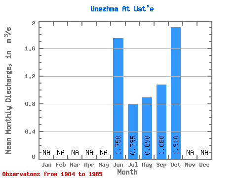
| Statistic | Jan | Feb | Mar | Apr | May | Jun | Jul | Aug | Sep | Oct | Nov | Dec | Annual |
|---|---|---|---|---|---|---|---|---|---|---|---|---|---|
| Mean | 1.75 | 0.80 | 0.89 | 1.08 | 1.91 | ||||||||
| Standard Deviation | 0.40 | 0.45 | 0.47 | ||||||||||
| Min | 1.75 | 0.51 | 0.57 | 0.75 | 1.91 | ||||||||
| Max | 1.75 | 1.08 | 1.21 | 1.41 | 1.91 | ||||||||
| Coefficient of Variation | 0.51 | 0.51 | 0.43 |
 Return to R-Arctic Net Home Page