|
|
|||||||||||||||||
| Point ID: 9081 | Downloads | Plots | Site Data | Code: 49150 |
|
|
|||||||||||||||||
| Download | |
|---|---|
| Site Descriptor Information | Site Time Series Data |
| Link to all available data | |
| View: | Time Series | All |
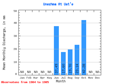
| Units: | m3/s |
| Statistic | Jan | Feb | Mar | Apr | May | Jun | Jul | Aug | Sep | Oct | Nov | Dec | Annual |
|---|---|---|---|---|---|---|---|---|---|---|---|---|---|
| Mean | 37.49 | 17.59 | 19.70 | 23.14 | 42.27 | ||||||||
| Standard Deviation | 8.92 | 10.02 | 10.00 | ||||||||||
| Min | 37.49 | 11.29 | 12.62 | 16.07 | 42.27 | ||||||||
| Max | 37.49 | 23.90 | 26.78 | 30.20 | 42.27 | ||||||||
| Coefficient of Variation | 0.51 | 0.51 | 0.43 |
 Return to R-Arctic Net Home Page