|
|
|||||||||||||||||
| Point ID: 9068 | Downloads | Plots | Site Data | Code: 49098 |
|
|
|||||||||||||||||
| Download | |
|---|---|
| Site Descriptor Information | Site Time Series Data |
| Link to all available data | |
| View: | Time Series | All |
| Units: | mm |
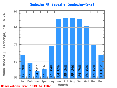
| Statistic | Jan | Feb | Mar | Apr | May | Jun | Jul | Aug | Sep | Oct | Nov | Dec | Annual |
|---|---|---|---|---|---|---|---|---|---|---|---|---|---|
| Mean | 63.70 | 59.28 | 54.53 | 55.72 | 69.04 | 84.90 | 85.31 | 85.35 | 84.71 | 80.84 | 69.82 | 64.01 | 71.12 |
| Standard Deviation | 27.15 | 28.35 | 23.01 | 23.41 | 27.27 | 22.63 | 18.20 | 46.91 | 41.24 | 40.84 | 32.98 | 26.75 | 17.50 |
| Min | 18.00 | 11.00 | 12.80 | 11.70 | 32.90 | 49.50 | 48.80 | 38.50 | 51.80 | 33.00 | 18.30 | 18.00 | 33.02 |
| Max | 129.00 | 136.00 | 99.80 | 121.00 | 138.00 | 141.00 | 113.00 | 296.00 | 245.00 | 228.00 | 168.00 | 115.00 | 110.52 |
| Coefficient of Variation | 0.43 | 0.48 | 0.42 | 0.42 | 0.40 | 0.27 | 0.21 | 0.55 | 0.49 | 0.51 | 0.47 | 0.42 | 0.25 |
 Return to R-Arctic Net Home Page