|
|
|||||||||||||||||
| Point ID: 9068 | Downloads | Plots | Site Data | Code: 49098 |
|
|
|||||||||||||||||
| Download | |
|---|---|
| Site Descriptor Information | Site Time Series Data |
| Link to all available data | |
| View: | Time Series | All |
| Units: | m3/s |
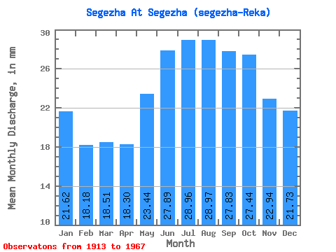
| Statistic | Jan | Feb | Mar | Apr | May | Jun | Jul | Aug | Sep | Oct | Nov | Dec | Annual |
|---|---|---|---|---|---|---|---|---|---|---|---|---|---|
| Mean | 21.62 | 18.33 | 18.51 | 18.30 | 23.43 | 27.89 | 28.95 | 28.97 | 27.83 | 27.44 | 22.94 | 21.73 | 284.47 |
| Standard Deviation | 9.21 | 8.77 | 7.81 | 7.69 | 9.26 | 7.43 | 6.18 | 15.92 | 13.55 | 13.86 | 10.83 | 9.08 | 70.01 |
| Min | 6.11 | 3.40 | 4.34 | 3.84 | 11.17 | 16.26 | 16.56 | 13.07 | 17.02 | 11.20 | 6.01 | 6.11 | 132.10 |
| Max | 43.78 | 42.06 | 33.87 | 39.75 | 46.84 | 46.32 | 38.35 | 100.47 | 80.49 | 77.39 | 55.19 | 39.03 | 442.07 |
| Coefficient of Variation | 0.43 | 0.48 | 0.42 | 0.42 | 0.40 | 0.27 | 0.21 | 0.55 | 0.49 | 0.51 | 0.47 | 0.42 | 0.25 |
 Return to R-Arctic Net Home Page