|
|
|||||||||||||||||
| Point ID: 9049 | Downloads | Plots | Site Data | Code: 49010 |
|
|
|||||||||||||||||
| Download | |
|---|---|
| Site Descriptor Information | Site Time Series Data |
| Link to all available data | |
| View: | Time Series | All |
| Units: | mm |
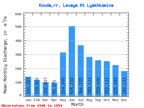
| Statistic | Jan | Feb | Mar | Apr | May | Jun | Jul | Aug | Sep | Oct | Nov | Dec | Annual |
|---|---|---|---|---|---|---|---|---|---|---|---|---|---|
| Mean | 140.34 | 118.80 | 102.84 | 99.38 | 314.00 | 505.22 | 366.22 | 283.11 | 259.00 | 252.11 | 225.33 | 182.11 | 240.76 |
| Standard Deviation | 45.33 | 30.60 | 23.07 | 20.77 | 128.75 | 154.59 | 79.63 | 77.50 | 100.29 | 123.64 | 99.62 | 69.58 | 58.52 |
| Min | 82.70 | 79.90 | 73.20 | 71.00 | 172.00 | 275.00 | 209.00 | 159.00 | 121.00 | 104.00 | 103.00 | 95.00 | 130.17 |
| Max | 202.00 | 156.00 | 128.00 | 128.00 | 476.00 | 748.00 | 464.00 | 381.00 | 394.00 | 475.00 | 350.00 | 260.00 | 309.67 |
| Coefficient of Variation | 0.32 | 0.26 | 0.22 | 0.21 | 0.41 | 0.31 | 0.22 | 0.27 | 0.39 | 0.49 | 0.44 | 0.38 | 0.24 |
 Return to R-Arctic Net Home Page