|
|
|||||||||||||||||
| Point ID: 9049 | Downloads | Plots | Site Data | Code: 49010 |
|
|
|||||||||||||||||
| Download | |
|---|---|
| Site Descriptor Information | Site Time Series Data |
| Link to all available data | |
| View: | Time Series | All |
| Units: | m3/s |
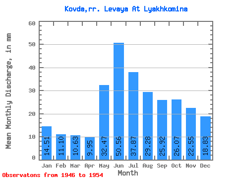
| Statistic | Jan | Feb | Mar | Apr | May | Jun | Jul | Aug | Sep | Oct | Nov | Dec | Annual |
|---|---|---|---|---|---|---|---|---|---|---|---|---|---|
| Mean | 14.51 | 11.19 | 10.63 | 9.95 | 32.47 | 50.56 | 37.87 | 29.27 | 25.92 | 26.07 | 22.55 | 18.83 | 293.37 |
| Standard Deviation | 4.69 | 2.88 | 2.39 | 2.08 | 13.31 | 15.47 | 8.23 | 8.01 | 10.04 | 12.78 | 9.97 | 7.19 | 71.31 |
| Min | 8.55 | 7.53 | 7.57 | 7.11 | 17.78 | 27.52 | 21.61 | 16.44 | 12.11 | 10.75 | 10.31 | 9.82 | 158.61 |
| Max | 20.89 | 14.70 | 13.23 | 12.81 | 49.22 | 74.86 | 47.98 | 39.40 | 39.43 | 49.11 | 35.03 | 26.88 | 377.34 |
| Coefficient of Variation | 0.32 | 0.26 | 0.22 | 0.21 | 0.41 | 0.31 | 0.22 | 0.27 | 0.39 | 0.49 | 0.44 | 0.38 | 0.24 |
 Return to R-Arctic Net Home Page